What is Route2School?
How do we make a difference?
Route2School MAP
Route2School Map inventories the infrastructure for vulnerable road users in a city or municipality. The focus is on the journeys made by schoolchildren to and from school.
This inventory is based on input from vulnerable road users themselves. This approach helps to build support among both the government and citizens.
Once the inventory has been completed, the local government will receive an overview of the bottlenecks in its territory. This overview serves as a starting point for working with citizens to prioritize and resolve these bottlenecks.
Once the inventory has been completed, the local community will also have a network of routes that are considered safe, less safe, and downright unsafe. This network serves as a starting point for further improvements AND as an important tool for making the safest choices when traveling to and from school.
Learning about road safety through play
Route2School Education
Route2School Education trains children and young people in road safety. They do this by logging into an online platform and completing a number of tests. These tests are designed in a way that is appealing to children and young people.
This training is based as much as possible on material (situations, bottlenecks) from the PARTICIPANTS' OWN environment. The use of familiar situations provides a great incentive. Much of the teaching material can be developed on the basis of data collected in a previous R2S-Map project.
The training takes into account the level and stage of development of the child or young person. We have a version for primary education and a version for secondary education.
A flexible "game element" has also been added to the Education platform. This allows children to track their individual progress, but also enables groups (such as classes) to compete with each other.
Tackling bottlenecks in a targeted manner
Route2School Expert
These bottlenecks were often identified in a previous R2S-Map project. The proposed solutions take into account local conditions and locally applicable regulations (road type, environment type, etc.).
If necessary, the analysis also includes a site visit so that the situation can be properly assessed. If necessary, this can be accompanied by an investigation using a drone.
The best solution is proposed from the total number of possible solutions. This solution may lead to infrastructure works, but also to measures relating to enforcement and education/awareness-raising.
The advice is provided in a format that can be used directly as input for local decision-making.
Tool for safe travel
Road Safety Route Planner
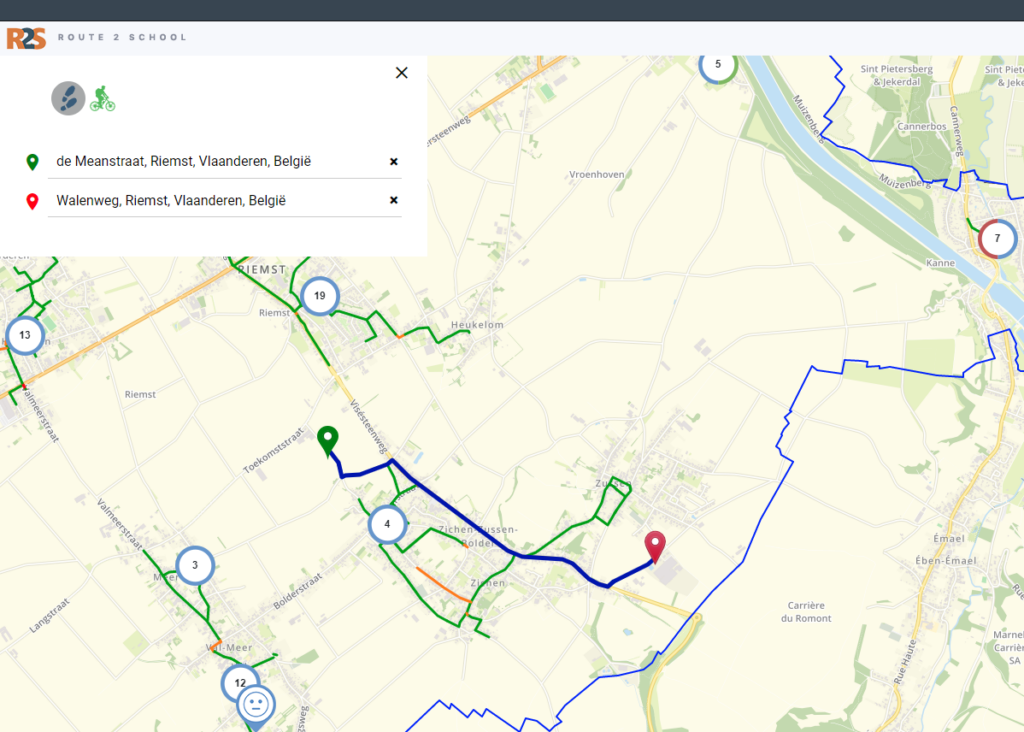
What is the Road Safety Route Planner?
- VR is a tool that citizens can use to get around as safely as possible.
- Citizens can request a route based on their starting point and destination. The VR then recommends a route that avoids dangerous sections and points as much as possible.
- The VR works for all vulnerable road users (cyclists and pedestrians).
- The VR avoids routes that are marked as unsafe or less safe as much as possible, and uses routes that are marked as safe as much as possible.
- The VR avoids situations where one has to cross or turn left as much as possible.
- The VR takes into account a maximum percentage of detour distance.
- The VR can be supplemented with explanations/comments on specific points that indicate how to move around as safely as possible at that location.
- In principle, VR can be created for any customer. The quality of the VR naturally depends on the level at which the underlying road network has been mapped.
How is the Road Safety Route Planner created?
-
We take the school route map as drawn up in the R2S Map project as our starting point. After all, this already provides important insight into the safety of residential/school traffic. The school route map can then be expanded based on the wishes and possibilities of the city/municipality.
The city or municipality can supplement the network itself using its own available information, such asbicycle route maps (recreational and functional), slow road maps, speed limits, known bottlenecks and safe crossings, roads with heavy traffic, known shortcuts, road categorization maps, public transport lines, etc.
-
Abeona can conduct an additional survey to further expand the coverage of the network used. To this end, a scientific method has been developed at Hasselt University that has been successfully implemented in various locations in Flanders.
-
Known bottlenecks (reports) from the R2S Map (and additional bottlenecks) can be processed into a "comments" layer that provides cyclists or walkers with further information about their route.